The Returning Giant – a Super El Niño Is Coming
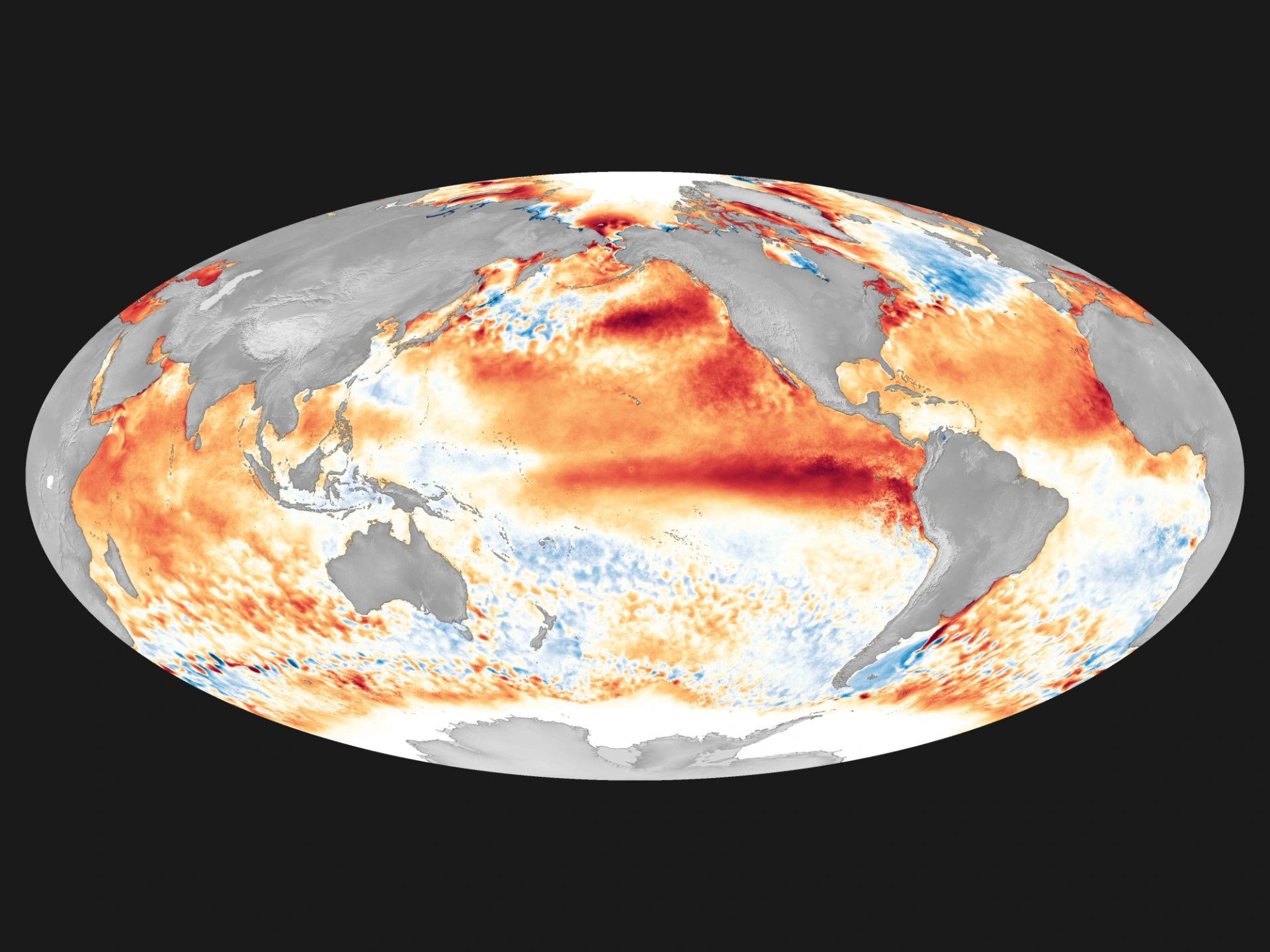
Climate scientists have long been watching the temperature of the Pacific Ocean at the equator, because we are facing a weather phenomenon that could rewrite the planet's rainfall and temperature patterns for many months. In spring 2026 the forecasts became increasingly clear: an extremely strong El Niño event is developing. The World Meteorological Organization (WMO) and many leading research institutes warn with one voice that the coming event could be the strongest El Niño on record.
What is El Niño?
El Niño – Spanish for "the little boy" – is a natural climate phenomenon in which surface water temperatures in the eastern half of the equatorial Pacific rise above average. Under normal conditions, the trade winds push warm water westwards, while deeper, colder layers rise to the surface along the eastern coasts. When these winds weaken, the warm water flows back east – and that is the start of El Niño.
The phenomenon occurs every two to seven years and lasts 9–12 months. Its strength can be measured: if the temperature in the relevant ocean zone rises 0.5 °C above average, it is a weak El Niño; above 2 °C it is a "super" El Niño.
Analysis by Zero Carbon Analytics has linked such extreme events to possible crop failures, wildfires, simultaneous droughts, increased flood risk and disruption to fisheries – and, as a result, to rising regional social tensions (Zero Carbon Analytics, n.d.).
What the models show
The WMO's latest Global Seasonal Climate Update shows clear signals: surface water temperatures in the equatorial Pacific are rising rapidly, and El Niño is expected to develop as early as May–July 2026 (WMO, 2026). According to the organisation's head of climate prediction, Wilfran Moufouma Okia, climate models are now strongly aligned and predict with high confidence the onset of El Niño, followed by further strengthening in the following months.
Zero Carbon Analytics puts the probability of El Niño developing in the May–July window at 61%. Some models are already projecting an extremely strong event. Jeff Berardelli, chief meteorologist and climate specialist at WFLA-TV, does not mince his words:
“I think we're going to see weather events that we've never seen in modern history before.”
One technical reason the forecasts are strengthening is that the unusually warm water layers moving deep in the Pacific – so-called Kelvin waves – are close to the largest and most intense ever recorded. These deep heat reservoirs are now breaking to the surface and will dramatically accelerate the event's development in the coming months.
Global impacts: heat, floods and drought at once
El Niño does not just affect the Pacific region – its effects are global. According to Berardelli, the phenomenon essentially redistributes the Earth's heat: when the ocean releases large amounts of heat into the atmosphere, the whole climate system speeds up. The consequences are stronger heatwaves, worsening droughts in some areas and, elsewhere, more intense floods because the air holds more moisture.
Paradoxically, the Atlantic hurricane season is subdued in such years: heat building up over the Pacific "draws" energy from the Atlantic, so fewer – but potentially stronger – tropical cyclones may form in the Caribbean.
According to Daniel Swain, a climate scientist at the California Institute for Water Resources, the combination of extra heat brought to the surface by El Niño and human-induced warming will lead to record global heat.
Both 2026 and 2027 are in the running to become the hottest year on record.
The Amazon rainforest is under particularly serious threat: some 40% of the forest has already been weakened by fires, logging and drought in recent decades, and a strong El Niño would put further strain on this sensitive ecosystem.
Europe in the crossfire
Although El Niño's effects are strongest in tropical and subtropical regions, Europe is not untouched. According to Zero Carbon Analytics, El Niño years typically bring wetter winters to southern Europe, while central and northern Europe see drier, colder spells.
The Climate Impact Company's 2026 European summer forecast, however, paints an even more worrying picture: a strengthening El Niño, a warm zone in the North Atlantic and a rainfall deficit across the Scandinavian–Baltic region together point to a severe summer drought affecting the whole continent.
In June a strong heat ridge could form over the United Kingdom, extending east as far as south-western Russia. July is expected to be hot and dry in western and central Europe, and in August dangerous late-summer heat and a lack of rain threaten central and eastern Europe.
The latest ECMWF model runs confirm this picture: they show an increasingly strong El Niño signature, forecasting a drier summer for central Europe and increased thunderstorm risk for southern Europe.
Risks to water and food
The consequences of El Niño go far beyond weather anomalies – they have a direct impact on drinking water supplies, agriculture and food security. As a result of the 2023–24 El Niño, more than 30 million people needed humanitarian assistance in southern Africa, where the region suffered its worst drought in 100 years, recalls the UN Office for the Coordination of Humanitarian Affairs (OCHA).
The EU's Joint Research Centre (JRC) has issued warnings of expected crop yield declines for the second half of 2026, citing El Niño's impact – given that drought and heat reduce soil moisture, slow plant growth and increase the need for irrigation, just as water sources are dwindling (JRC, 2026).
Ocean impacts are not negligible either. NASA researchers have found that strong El Niño events can dramatically reduce phytoplankton, the basis of marine food chains.
The 1997–98 El Niño caused the anchovy fishery off Chile to collapse – this could happen again in 2026, bringing global declines in fish stocks and tensions over food policy.
Climate change amplifies the effect
El Niño itself is a natural phenomenon not caused by human activity. But climate change is creating ever more fertile ground for such events. According to Zero Carbon Analytics, the number of extreme El Niño and La Niña episodes has increased since the 1950s, and some projections suggest the number of extreme El Niño events could double as global warming continues.
Michael Mann, a climate scientist at the University of Pennsylvania, adds nuance: El Niño may push up global temperatures for a year or two, but in the long run it is a "zero-sum game". The real danger is that an extraordinary El Niño is stacked on top of a baseline already raised by man-made warming – and that combination could bring new records.
What to expect this year
The 2026 El Niño is still developing, but the signs are consistent: a strong, possibly record-breaking event is approaching. The WMO, the ECMWF and leading climate scientists all consider highly likely an event that could bring heatwaves, droughts, intense floods and wildfires – at the same time, reinforcing each other, in many parts of the world. According to the forecasts, Europe – and especially Central Europe – will be directly in the path of summer drought and increased heat stress. For water infrastructure and food production, this half-year will be a serious test – even if the final intensity is still uncertain.
In spring 2026, climate models agree that an extremely strong El Niño event is likely to develop. The World Meteorological Organization (WMO) expects the phenomenon to arrive as early as May–July 2026, possibly followed by further strengthening. Zero Carbon Analytics puts the probability at 61%, and some models point to a "super" El Niño that could rival the record event of 1997–98. The effects are global: stronger heatwaves, more intense floods, worsening droughts, wildfires and disruption of marine ecosystems are expected. Europe will not be untouched – according to the Climate Impact Company's forecast, severe drought and dangerous heat could sweep across Central and Eastern Europe in summer 2026. The EU's Joint Research Centre (JRC) has issued agricultural warnings for the second half of the year. Climate change amplifies the natural phenomenon: together, El Niño and human-induced warming could make 2026 or 2027 the hottest year on record.
One of 2026's most serious climate challenges is an extremely strong, possibly record-breaking El Niño taking shape in the Pacific. According to the World Meteorological Organization's (WMO) latest global seasonal update, surface water temperatures are rising rapidly, and El Niño is expected to develop as early as May–July 2026, followed by further strengthening in the months that follow. Zero Carbon Analytics puts the probability of its development at 61%, and some models project a "super" El Niño – a temperature anomaly of 2 °C or more.
El Niño essentially redistributes the Earth's heat: it makes heatwaves stronger and intensifies droughts in some regions, while elsewhere increased atmospheric moisture causes more intense floods. Some 40% of the Amazon rainforest is already vulnerable, and a strong El Niño could make this worse. The Atlantic hurricane season is subdued, but the Caribbean faces increased drought.
Europe is particularly affected: according to the Climate Impact Company's forecast, severe drought and dangerous late-summer heat could sweep across Central and Eastern Europe in summer 2026, extending into south-western Russia. Analysis by Severe Weather Europe confirms that the latest ECMWF model runs show an increasingly strong El Niño signature for Central Europe.
The risks to water and food are global. The EU's Joint Research Centre (JRC) has issued wide-ranging agricultural warnings for the second half of 2026. The 2023–24 El Niño already left more than 30 million people in humanitarian need in southern Africa. Climate change amplifies the effect further: projections suggest the number of extreme El Niño events could double as global warming continues, and 2026 or 2027 could be the hottest year on record.



A study of 10,826 Chinese treatment plants finds that big centralised systems are reaching two limits at once, on easing water scarcity and on paying their way, and that a hybrid model could do the job for up to 37% less.
FAO has published draft principles on who may use water and on what terms, a quiet piece of international work that speaks directly to this year's fights over drought, wells and free irrigation.

A new report projects data centres' water footprint reaching 9.32 trillion litres by 2030, but the number is only meaningful once you know what it counts, and who is making the case.

An English coalition has costed what it would take to keep every drop of wastewater out of England's largest lake, £3.6–3.7 billion, and its modelling says nothing less ends harmful algal blooms.